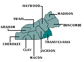
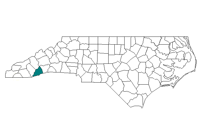
TRANSYLVANIA COUNTY
Scroll down this page or click on site name to view features on the following Transylvania County attractions/points of interest:
Allison-Deaver House, Brevard Music Center, Cradle of Forestry in America, DuPont State Forest, Gorges State Park, Pisgah Astronomical Research Institute, Pisgah Center for Wildlife Education, Transylvania County Heritage Museum
Fast facts about Transylvania County:
Created in 1861; the county name is derived from the Latin words “trans,” meaning across, and “sylva,” meaning woods.
The county seat is Brevard, named in honor of Ephriam Brevard, author of the Mecklenburg Declaration of Independence of May 20, 1775. Other communities include Cedar Mountain, Cherryfield, Lake Toxaway, Little River, Penrose, Pisgah Forest, and Sapphire.
Transylvania County’s land area is 378.39 square miles; the population in 2010 was 33,090.
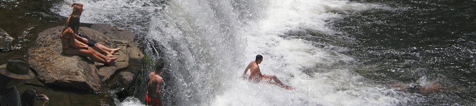
It is worth noting that Transylvania County is known as “The Land of Waterfalls.”
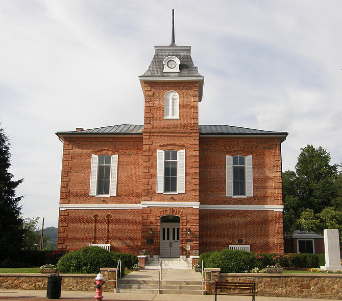
Below: Transylvania County Courthouse, Brevard
Pisgah Forest

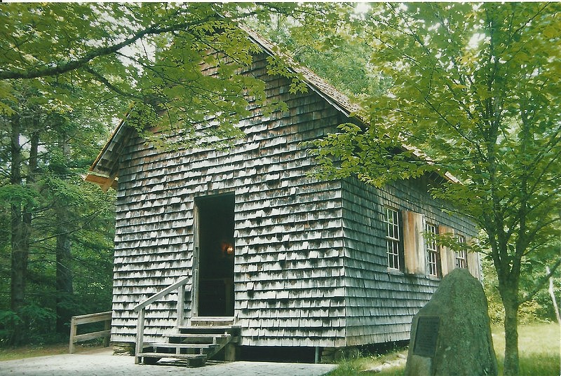
The Allison-Deaver House in Pisgah Forest near Brevard, maintained and operated by the Transylvania County Historical Society, has the distinction of being North Carolina’s oldest known standing frame house west of the Blue Ridge Mountains. Built in 1815 by Benjamin Allison, the earliest section of the house was a modest two-story federal-style dwelling with 1,100 square feet. In 1830, Allison sold his house and property to land speculator, merchant, and farmer William Deaver. Sometime around 1840, Deaver dramatically altered the appearance of the home by attaching a Greek Revival addition that doubled the size to 2,200 square feet and by placing a distinctive double porch across the entire front. Fortunately for today’s visitors, interested in taking a glimpse into the past, the Allison-Deaver House never underwent any major modernization in the years which followed. Plumbing and heating were not added, nor were closets. As a result, visitors see working fireplaces; original paneling, molding and trim; and original paint finishes. Costumed docents provide guided tours of all first and second floor rooms and the attic.
The Allison-Deaver House is on the National Register of Historic Places and is one of the stops along the North Carolina Civil War Trail. During the closing months of the war, a case of mistaken identity cost William Deaver his life. Two of his sons, James and Robert, had enlisted in the Confederate Army. James Deaver gained the rank of captain. Stationed in Hendersonville, he was responsible for procuring food and supplies for Confederate troops and for dealing with deserters, renegades, and bushwhackers in the area. One day in early 1865, Captain Deaver, while in pursuit of some deserters, took advantage of his proximity to home and paid a brief visit to his family. Some of the men he was pursuing, having learned where Deaver was, attempted an ambush. By the time they arrived at the house, James Deaver had already gone. When the men called out for Captain Deaver to come to the door, therefore, it was William Deaver – who had been a captain in the Buncombe County militia many years earlier – who answered. Before anyone realized it was the father, not the son, standing on the porch, shots were fired, and William Deaver fell mortally wounded. The house is located just north of the intersection of US 64 and NC 280 near Pisgah Forest. Hours are 10-4 Saturday and 1-4 Sunday from mid-May through mid-October. Admission charged. 828-884-5137
Brevard
The Brevard Music Center [BMC] offers a mid-summer medley of musical programs at the open-air Whittingham-Pfold Auditorium. Along with programs featuring the Brevard Music Center Orchestra, conducted by BMC alumnus Keith Lockhart, guest conductors and performers fill the six-and-a-half week summer schedule with programs almost every night, as well as a few afternoon performances. 828-862-2105
North of Brevard

The Cradle of Forestry in America in the mountains of western NC is home to a school almost everyone will enjoy attending, if only for a few hours. In 1968, the US Congress set aside 6,540 acres of Pisgah National Forest for the purpose of preserving the birthplace of forestry and forestry education in America. As the land within its boundaries was the location of the first school of forestry in the US, the site was rightfully given the name “The Cradle of Forestry in America.” As visitors will discover, to make is “cradle” "rock" requires the coordinated efforts of two organizations. The “Cradle of Forestry in America” is a US Forest Service site. The Cradle of Forestry Interpretive Association is a non-profit organization that works in concert with the Forest Service to operate the Forest Discovery Center at the “Cradle.” Visitors can walk two interpretive trails, both of which are paved and handicapped-accessible, and enjoy educational exhibits within the impressive Discovery Center building itself.
In 1892, George Vanderbilt hired Gifford Pinchot to be a forester on the Biltmore estate. Trained in France, Pinchot brought to his job a scientific approach to forest management, and in 1898, President McKinley appointed Pinchot to be the first chief of what would eventually become the US Forestry Service. The first school of forestry in the US was established in 1898 by German forester Dr. Carl Alwin Schenck in what was known as the Pink Beds community. Called the Biltmore Forest School, several rough-hewn buildings comprised its campus, many of which are seen today along the Biltmore Campus Trail. Among them are the single-room schoolhouse, the commissary, the blacksmith shop, Dr. Schenck’s office, and the students’ quarters. Taped messages at each location provide information about the building and its uses.
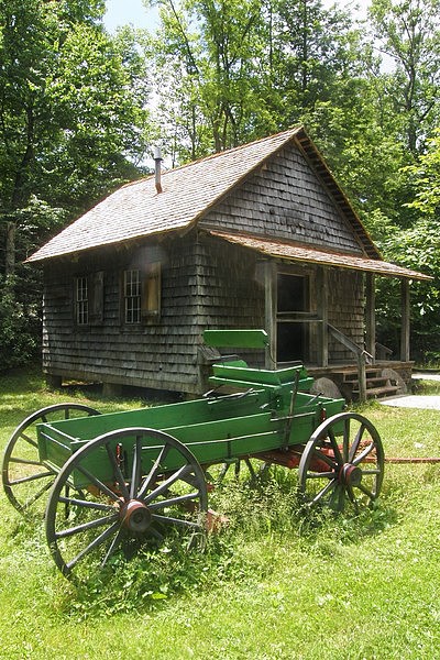
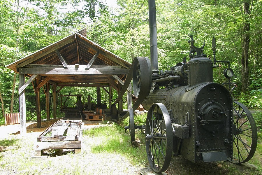
The Pink Beds commissary, for example, in addition to being the source for basic staples, was also the community gathering place and served as the post office. The student quarters were a far cry from today’s relatively comfortable dorm rooms, as the names forestry students gave their lodgings – “Gnat Hollow,” “Rest for the Wicked,” and “Hell Hole” – would suggest. In Dr. Schenck’s office are presses used for book binding, very appropriate considering that many of the educator’s lecture notes were published in book form. The Forest Festival Trail winds its way in the opposite direction from the Biltmore Campus Trail. Along this path visitors will pass by a steam-powered portable saw mill and a Climax narrow-gauge railroad engine, primarily used in logging and mining operations. Climbing aboard the engine and ringing the bell are favorite activities for the kids. Adults may be inclined to climb as well.
Inside the Discovery Center building visitors will see numerous exhibits showcasing the development of forestry. Among the artifacts on hand is a Biltmore stick, first developed at the school and used to measure the diameter and height of a tree, from which numbers a forester can determine how much lumber that tree will yield. A new fantasy film entitled “There’s Magic at the Cradle” is shown in the auditorium. It’s about a 12-year-old girl who has no interest in nature until she is magically transported into an outdoor adventure. The “Cradle” is located on the 79-mile Forest Heritage National Scenic Byway, which loops its way through the southwestern section of the Pisgah National Forest. On the stretch of US 276 heading north from Brevard to the “Cradle,” you’ll pass by Looking Glass Falls and the Sliding Rock Recreation Area (fee required). From US 64 east of Brevard, take US 276 North for 11 miles to the Cradle of Forestry. Hours are 9-5 daily from mid-April through early November. Admission charged. 828-877-3130
East of Brevard

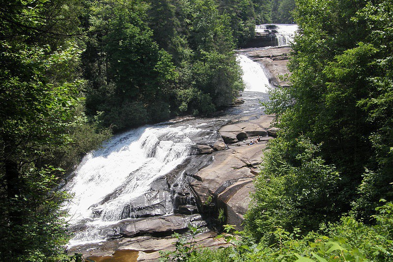
Transylvania County calls itself “The Land of Waterfalls” and several of the largest and prettiest can be seen at DuPont State Forest, a 10,400-acre tract that straddles the Henderson-Transylvania county line. Visitors may experience a sense of déjà vu when viewing several of the waterfalls at DuPont, even if they've never been here before. That’s because Hooker, High, Triple, and Bridal Veil Falls were all used as backgrounds in the 1992 movie Last of the Mohicans starring Daniel Day-Lewis. Three of the cascades are easy to reach from the Hooker Falls parking lot. The smallest of the three, and the easiest to get to, is the one that lends its name to the parking area. Hooker Falls is about a ¼-mile walk along a mostly-level gravel road. It’s less than 15 feet in height, and there is a large pool at the base that makes for a very popular swimming hole. Expect large crowds on summer weekends.
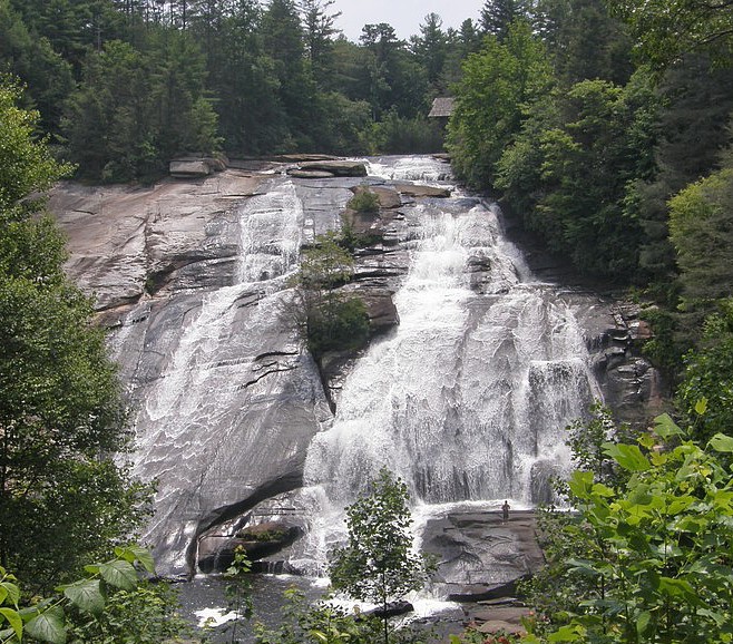
Triple Falls is just what the name implies – a series of three falls, each with its own pool. The three-in-one cascade can be viewed in all its splendor from an observation area along the main trail, or you can take paths leading down to the base of each individual fall. It’s about a half-mile walk from the parking area to the trail view; the walk is rated easy to moderate. From here, it’s another three-quarters of a mile uphill to the trail view of High Falls. This impressive cascade has a 100-foot vertical drop and is especially grand when water levels are high. A steep path leads down to the base of the falls, and, once again, you can expect lots of people to be picnicking, sunbathing, or simply splashing around in the water on summer days. From the trail view, you’ll see a covered bridge extending over the falls at the top. To reach this, continue up the trail for short distance, then turn left onto Buck Forest Road and follow the trail to the bridge.
Visitors still feeling adventurous can finish crossing the bridge and follow the road a short distance to Conservation Road. Turn right onto Conservation Road, walk abouta half mile, then turn right onto Bridal Veil Falls Road. It’s another half-mile or so to where the road ends near the base of the waterfall. The drop is only 10 feet, and there is a small area you can get to behind the behind the curtain of water. Visitors likely find this waterfall less crowded than those mentioned previously. Another cascade that draws few visitors is Grassy Creek Falls. Nothing too splashy about this one, but it’s photogenic in its own way. To get to this fall, go past Conservation Road and turn left on Lake Imaging Trail. This path will lead to the Grassy Creek Falls trail on the left. DuPont has nearly 100 miles of trails, most of which are used for biking and horseback riding in addition to hiking. All parking areas have portable toilet facilities and information boards with maps.
South of Sapphire
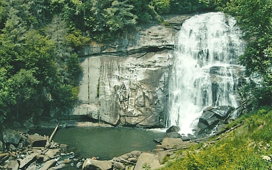
Gorges State Park, established in 1999 and encompassing 7,500 acres, is one of the newest in North Carolina's extensive park system, with many of its facilities still under development. Located in Transylvania County, and bordering South Carolina, Gorges also has the distinction of being North Carolina’s westernmost state park. Gorges State Park provides excellent opportunities for hiking, biking, fishing, boating, and camping. The park’s most popular trail, going to Rainbow Falls, actually leads out of the park and into the Pisgah National Forest. After ¾ mile – mostly downhill – the trail crosses over the park boundary and continues another ¾ mile – mostly uphill – to Rainbow Falls. The path is well-shaded, but definitely strenuous. Less than a quarter-mile beyond the picturesque Rainbow Falls is Turtleback Falls, less photogenic but equally popular. The Bearwallow Valley Overlook Trial is self-descriptive – a half-mile path of moderate difficulty leads to one of the highest points in the park. The overlook, 3,200 feet above sea level, provides views of the valley as well as Lakes Jocassee and Keowee. Another half-mile trail, this one rated strenuous, leads to Upper Bearwallow Falls, a 200-foot cascade. All three of these trails are located in the Grassy Ridge Access Area in the western section of the park. The Frozen Creek Access Area, in the park’s eastern section, is much more remote and features several longer trails which will appeal to more experienced hikers.
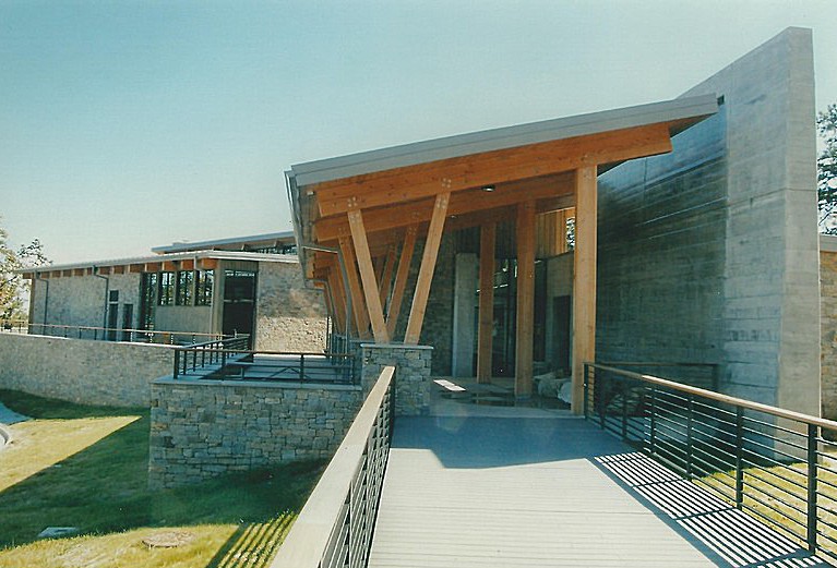
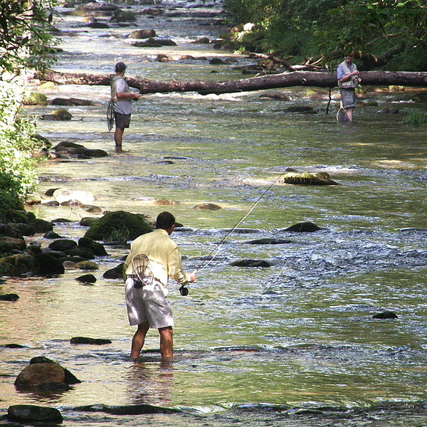
Bear Wallow Creek and Tox-away River flow through the park, providing for some good fishing, and rainbow trout and smallmouth bass are among the common catches. State wildlife regulations apply. Lake Jocassee straddles the state line and boat access is located at Devil’s Fork State Park in South Carolina. Primitive camping is offered in several areas of the park. Gorges State Park is still undergoing development, and two of the most desirable amenities – a visitor center and restrooms – were just completed in 2012. Park hours are 8-9 June-August, 8-8 March-May, September, and October, and 8-6 November-February. No admission fee.
Rosman

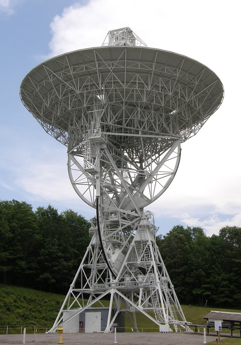
One of the most unusual attractions in all of North Carolina is the Pisgah Astronomical Research Institute [PARI], a site located deep within the Pisgah National Forest near Rosman – “near” being a relative term. Instead of towering pines, visitors to PARI will find two towering telescopes with receiving dishes 85-feet in diameter that are used to capture electromagnetic waves from deep space. Each telescope weighs 400 tons. Along with these two telescopes, PARI’s 200-acre campus includes two smaller radio telescopes, eight optical telescopes, and 30 buildings, including classrooms and a cafeteria.
2013 marked the 50th anniversary of the facility. Originally called the Rosman Tracking Station, the site was established in 1963 to be used by NASA to advance space exploration and PARI was involved in both the Gemini and Apollo projects. PARI’s antenna picked up and passed along the moon message heard around the world -- “The Eagle has landed.” From 1981 to 1994, PARI’s mission was entirely different. Used by the Department of Defense as a listening post, it helped to provide national security. Beginning in the mid-1990s, the National Forest Service acted as caretaker for the site before it was converted for use as an education center. To achieve this literally took an act of Congress, to establish a not-for-profit foundation, and a land swap, the PARI site in exchange for 200 acres along the French Broad River. That accomplished, PARI’s major objectives in the 21st century are scientific research, education, and public outreach.
Visitors are welcome to take self-guided tours of the campus from 9-4 Monday through Friday, but they are especially encouraged to participate in guided tours given Wednesday afternoons at 2 PM. Showcased on the tour are items that came from space – meteorites – and items that went into space – patches, pins, postcards, coins, flags, and other memorabilia – onboard various space craft. There are mementos from Apollo-Soyuz, the first international manned space mission in July, 1975. There is also a small section of the leading edge of a shuttle wing on display. It was the rupture of this wing by a small piece of foam that caused the in-flight break-up of the shuttle Columbia shortly after take-off on February 1, 2003, resulting in the loss of all seven crew members. Outside, visitors will notice that the buildings are all painted NASA-blue, a particular shade that has actually been trademarked. Also outside is the scale model “Galaxy Walk.” A 4-inch ball represents the position of the Sun; a step or two away is Mercury, followed closely by Venus, then Earth. Mars is a bit further out; Saturn, Jupiter, Uranus, and Neptune follow at greater distances, but still within sight of the buildings; Pluto, however, is over the hill and out of sight. To put things in perspective, the nearest star to our planet is Alpha Centura – if this body were represented on PARI’s Galaxy Walk, the marker would be located in Tucson, Arizona!
Reservations for guided tours are required and can be made by calling 828-862-5554. Tours last approximately 90 minutes and there is a $5.00 per person fee for everyone 10 and older. The “Evening at PARI” program, held on the second Friday of each month, includes a tour and, if weather permits, the use of an optical telescope to view Earth’s moon, the planets, and/or other celestial bodies.
Pisgah Forest
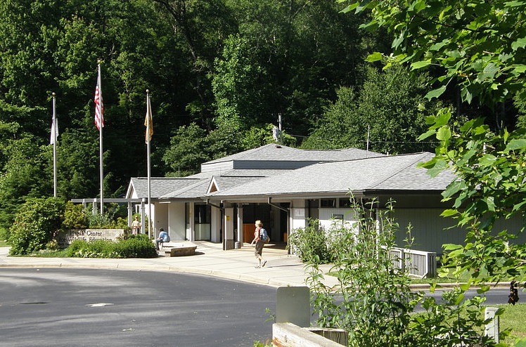
The Pisgah Center for Wildlife Education and the adjoining Bobby N. Setzer State Fish Hatchery, both administered by the North Carolina Wildlife Resources Commission, are tucked away within the pleasant confines of the Pisgah National Forest outside Brevard. Indoor displays at the Visitor Center exhibit fish, toads, turtles, salamanders, and snakes found in the mountains. Outdoors, immediately behind the building, is a model backyard wildlife garden, displaying imaginative ways in which home landscaping can be used to create welcoming habitats for birds, butterflies, and small animals. A short, handicapped-accessible trail starts at the garden and loops though a hardwood forest habitat. At the hatchery, the largest trout hatchery in the state, brook, rainbow, and brown trout are raised for the purpose of supplying the Commission’s hatchery-supported streams. The Center is open 8-4 daily except for most state holidays; admission is free. 828-877-4423
Brevard
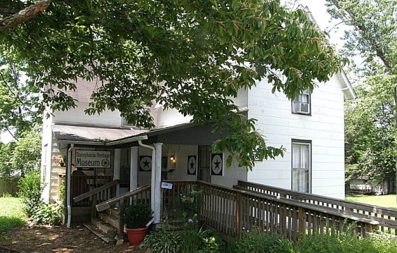
The Transylvania County Heritage Museum is located in the former home of Thomas D. England, a nephew of Alexander England, one of three men who donated land to form the county seat of Brevard when the county was established in 1861. The Museum opened in May, 2008 and includes permanent and temporary exhibits pertaining to the history and heritage of Transylvania. Hours are 10-5 Wednesday through Saturday from March through mid-December. 828-884-2347
Transylvania County is bordered by HAYWOOD, HENDERSON (Region Nine), and JACKSON counties.
Return to REGION TEN HOME PAGE.
Return to GEOGRAPHIC REGIONS HOME PAGE.